se7entythree
YOSHIYOSHI
17375 Posts
user info
edit post |
| Quote : | "I fail to see how it isn't a real GPS. If you have signal it's an assisted GPS and therefore better/faster than a regular GPS and if you don't have a cell signal than it's just as good.
The screen is better, you have more map options, typically more storage space for maps, and it's smaller and has a decent battery life (assuming you're not using lots of data). I used one for an entire day last time i went hiking checking my position a couple times an hour and the battery was down to 78% by the time the hike was over.
If you already have one I wouldn't buy a dedicated GPS unless you want to carry around something else. If you don't I agree you shouldn't buy an iPhone just for the GPS but smartphones are getting to the point where stand alone GPS's are becoming obsolete." |
^this.
i used mine over 4 days, no charging, only turning it on when i needed to check where i was and i made 2 phone calls. i still had 60something% charge. i brought a little backup battery charger thing just in case. i looked into getting a handheld gps but couldn't find any features available there that aren't on the iphone, except for the ruggedness/weatherproofness. i got a clear case that covered the screen too and put it in a ziploc bag. it'll work through the bag.
separate but somewhat related story: right after we got our iphones, my dumbass brother went on a friend's boat into the ocean. the boat was old as shit and had known electrical problems. they took no food or water bc they were in a hurry to get out there and fish before they ran out of daylight. all electronics on the boat failed. no radio, no gps. the engine quit too. it was dark by this point. my brother called seatow & gave them the coordinates from the iphone's compass app and it led them right to the boat. seatow said they were dead on.
[Edited on August 16, 2010 at 2:25 PM. Reason : ] 8/16/2010 2:21:52 PM 8/16/2010 2:21:52 PM
|
Skack
All American
31140 Posts
user info
edit post |
I camped at Cape Hatteras this weekend.
Just a Coleman tent, a couple blankets, a pillow, and my big agnes sleeping pad loaded in the truck for my camping gear.
Not a bad deal...Fish, swim, and drive on the beach all day then drop $20 in a box to set up a tent and go to sleep. There is a bathroom/showers for the morning. 8/16/2010 3:39:10 PM |
MeatStick
All American
1165 Posts
user info
edit post |
I'm camping for a weekend on Cape Lookout.
I think I 'm going to just get really good at a compass and maps, and hold onto my ass. I don't have the funds for a GPS right now, and I hate Iphones, tho I'm not opposed to borrowing.
The AT is really well marked, anyway, from what I heard...and worse comes to worse, I go in the wrong direction and still end up at a decent shelter. Least it'll be an adventure?
Do the trails have random signs/makers for the areas your in? Like if i start out at Carvers, are there signs pointing towards Roan? 8/16/2010 3:45:59 PM |
neodata686
All American
11577 Posts
user info
edit post |
Do you know how to read a topo map with a compass? Shooting azimuths? Pacing? Read up on topo map navigation. It's pretty neat when you get the hang of it. You'll start to notice where you are based upon ridges, knolls, reentrant, spurs, etc. Learning how to triangulate your position with a compass/map using peaks/known points is fun too. 8/16/2010 3:51:48 PM |
se7entythree
YOSHIYOSHI
17375 Posts
user info
edit post |
just know whether you're traveling north or south. don't look at the compass b/c it's backwards in that section. if you start at carvers and head toward roan, you're southbound. the trail is marked well and is very obvious (like worn down to the dirt and it's not a deer trail). water that's off the trail a bit is blazed blue.
examples of the white blaze


trail head toward roan (where those binoculars are) http://tinyurl.com/27llgf8
me sitting at that location 
[Edited on August 16, 2010 at 4:02 PM. Reason : STOP IT CODE] 8/16/2010 3:54:35 PM |
Nerdchick
All American
37009 Posts
user info
edit post |
you should be fine, just stay on the trail. IMO a GPS isn't really necessary on the AT. 8/16/2010 3:55:10 PM |
se7entythree
YOSHIYOSHI
17375 Posts
user info
edit post |
if we didn't have strict time deadlines and had been left behind by the rest of our group, we wouldn't have been as concerned w/ location & gps. 8/16/2010 4:02:46 PM |
MeatStick
All American
1165 Posts
user info
edit post |
I'm getting more pumped. Main objective is to figure out if i what to do with my car and if i want to back-track or shuttle.
I got a few maps today, a National Geographic map etc. Learning to use a compass this weekend from a friend who does all that stuff for fun.
My father just called me to tell me the plot of "The Blair Witch Project' in order to deter me from doing this  8/16/2010 7:19:52 PM |
Fumbler
All American
4670 Posts
user info
edit post |
Tote a gun.
Problem solved. 
I brought my Ruger LCP with me on the AT. 8/16/2010 9:52:33 PM |
Nerdchick
All American
37009 Posts
user info
edit post |
^^ people are just more afraid of unkown dangers. There have been 7 or 8 murders on the AT in the past 40 years, out of millions of yearly visitors. In North Charleston, where I live, there were 14 murders in the year 2008. You're vastly more likely to be hurt or killed on the drive to the trail than on the trail. 8/16/2010 11:30:14 PM |
Fumbler
All American
4670 Posts
user info
edit post |
Yeah...the likelihood of a bear mauling is even more remote.
I still tote a gun almost everywhere though. You never know what lunatic or pack of wild dogs you'll run into. 8/16/2010 11:41:28 PM |
quagmire02
All American
44225 Posts
user info
edit post |
| Quote : | | "I fail to see how it isn't a real GPS. If you have signal it's an assisted GPS and therefore better/faster than a regular GPS and if you don't have a cell signal than it's just as good." |
the clencher (in two ways): "if you have signal"
depending on which iphone you have, your chipset options are either the broadcom BCM4750 or the infineon PMB2525 (3g/4g, respectively...i think), but both of these chips are worse in performance (acquisition, tracking sensitivity, channel count, and power performance) than the MTK II and SkyTrac Venus 6, both of which are available in GPS units as cheap as $50 (though closer to $100+ if you want certain features to rival the iphone, i agree)...i backpack with friends who each have a droid and an iphone, and my MTK II chip consistently performs better than their phones...the only common chip the iphones perform better than is the 65nm SiRF III
also, i assume you're joking if you're trying to say that AT&T's service makes it better...again, the caveat is "if you have signal" and so the A-GPS "feature" is even worse to depend on than the chipset...no one touts AT&T's service as a plus because, well, GSM is great if you live in a city or next to an interstate...past that, you might as well pray you don't ever need to make a call out in an emergency
i'm certainly not saying it won't work as a GPS...if you're in a place where you know you'll have signal and cloud cover, foliage, rock outcroppings, etc won't be an issue (ie. walking along a ridge rather than a valley), it works just fine and i'd certainly never advise someone to go out and buy a replacement just because
but for those of us that don't necessarily travel big, popular ridge trails and happen to travel abroad fairly often (unless you're saying paying for the GSM service out of the country is another "benefit" of A-GPS?), the idea of depending on a smartphone is just silly...makes more sense to pay for a "real" GPS that performs better in every way and doesn't rely on a cellular plan
*shrug*
[Edited on August 17, 2010 at 7:47 AM. Reason : bah]8/17/2010 7:43:54 AM |
se7entythree
YOSHIYOSHI
17375 Posts
user info
edit post |
well um seeing as how we were talking about the AT, it made sense to discuss the fact that iphone works well for locating yourself on the AT. i never had a problem w/ gps signal and you don't need cell signal to have gps signal. in this situation, it's a better idea to carry one device and save the weight. 8/17/2010 9:46:41 AM |
neodata686
All American
11577 Posts
user info
edit post |
| Quote : | | "no one touts AT&T's service as a plus because, well, GSM is great if you live in a city or next to an interstate...past that, you might as well pray you don't ever need to make a call out in an emergency" |
You're vastly over exaggerating everything. AT&T's edge coverage is almost everywhere Verizon's is. I can make calls/receive data (although not as fast on edge) almost anywhere a Verizon phone can. True, 3G is not as widely dispersed as Verizon's but when i'm on 3G (especially in Charlotte) my speeds are vastly faster than Verizon. I get 5-6mbit down and 1.5mbit up (3 times as fast as Time Warner Cable) on 3G in Charlotte.
I'd rather sacrifice the maybe 3 times a year where I MIGHT not have service and get fast internet than get slow Verizon service. (oh and BTW on my last 2 hikes the Verizon phones didn't get service where we were).
| Quote : | "depending on which iphone you have, your chipset options are either the broadcom BCM4750 or the infineon PMB2525 (3g/4g, respectively...i think), but both of these chips are worse in performance (acquisition, tracking sensitivity, channel count, and power performance) than the MTK II and SkyTrac Venus 6, both of which are available in GPS units as cheap as $50 (though closer to $100+ if you want certain features to rival the iphone, i agree)...i backpack with friends who each have a droid and an iphone, and my MTK II chip consistently performs better than their phones...the only common chip the iphones perform better than is the 65nm SiRF III
" |
I don't understand your point. The iPhone picks up a signal within seconds of opening my topo app (without cell signal). Acquisition is plenty fast for me. Tracking sensitivity might be off by a couple yards but seriously? Are you THAT bad a hiker that you have to rely on a GPS constantly to obtain your position?
| Quote : | | "i'm certainly not saying it won't work as a GPS...if you're in a place where you know you'll have signal and cloud cover, foliage, rock outcroppings, etc won't be an issue (ie. walking along a ridge rather than a valley), it works just fine and i'd certainly never advise someone to go out and buy a replacement just because" |
I've never been in a place where it wouldn't pick up a GPS signal. I still think you're vastly exaggerating the difference between a dedicated GPS unit and an iPhone. I've been on plenty of hikes with it and its never failed me. Maybe that's because I know how to read a map and use a compass. I don't know. Half the time I don't even bring a GPS or turn on my phone unless i'm completely lost.
| Quote : | "i backpack with friends who each have a droid and an iphone, and my MTK II chip consistently performs better than their phones...the only common chip the iphones perform better than is the 65nm SiRF III
" |
There's courses you can take to get off your GPS addiction. It's kind of cheating. For the few times I want to see my position the maybe 1 second longer acuisition time of the iPhone's GPS is fine for me. I've been out in the mountains for 21 days+ without GPS assistance relying on a map/compass on various leadership trips and there was always "that guy" who complained about having to use a map/compass and missed his GPS.
*shrug*8/17/2010 9:58:23 AM |
se7entythree
YOSHIYOSHI
17375 Posts
user info
edit post |
i can attest from our trip 2 weekends ago that south of asheville around gerton/chimney rock/lake lure, verizon doesn't work and at&t does. i had over half to full signal the whole time. there is 0 verizon signal there. just sayin'
[Edited on August 17, 2010 at 11:02 AM. Reason : ] 8/17/2010 11:02:20 AM |
quagmire02
All American
44225 Posts
user info
edit post |
| Quote : | | "well um seeing as how we were talking about the AT, it made sense to discuss the fact that iphone works well for locating yourself on the AT. i never had a problem w/ gps signal and you don't need cell signal to have gps signal. in this situation, it's a better idea to carry one device and save the weight." |
well um seeing as how my comment is in regards to how the iphone sucks compared to real GPS units in general, it made sense to bring it up when the iphone was mentioned
| Quote : | "You're vastly over exaggerating everything. AT&T's edge coverage is almost everywhere Verizon's is. I can make calls/receive data (although not as fast on edge) almost anywhere a Verizon phone can. True, 3G is not as widely dispersed as Verizon's but when i'm on 3G (especially in Charlotte) my speeds are vastly faster than Verizon. I get 5-6mbit down and 1.5mbit up (3 times as fast as Time Warner Cable) on 3G in Charlotte.
I'd rather sacrifice the maybe 3 times a year where I MIGHT not have service and get fast internet than get slow Verizon service. (oh and BTW on my last 2 hikes the Verizon phones didn't get service where we were)." |
your points regarding speed rates are completely irrelevant in a discussion regarding a real GPS and A-GPS phones with inferior chips...you yourself said that AT&T 3G is not as widely dispersed as verizon's, so your earlier stance that qualifies A-GPS as being "better/faster" is completely dependent on having coverage, at which you have just admitted AT&T is inferior...a REAL GPS doesn't require cellular service to work, and it will last a helluva lot longer than a phone that keeps searching for a signal (and if you turn off your phone's ability to connect to 3G, we're back to the comparison of chips since A-GPS is no longer a factor, and the iphone doesn't perform nearly as well)
| Quote : | | "I don't understand your point. The iPhone picks up a signal within seconds of opening my topo app (without cell signal). Acquisition is plenty fast for me. Tracking sensitivity might be off by a couple yards but seriously? Are you THAT bad a hiker that you have to rely on a GPS constantly to obtain your position?" |
you don't understand my point because you obviously know nothing about GPS past what your pretty phone tells you about it...i have no doubt that out in the open on top of a ridge your iphone will get a signal as quickly as any other...and if that's all the hiking/camping/backpacking you do, then your phone is fine
for the rest of us that do more than just the popular stuff on top of mountains, your phone is vastly inferior, slower, less rugged and less waterproof...i realize YOU are okay with that, but some of us like to do more challenging things in places that aren't always so close to a tower (or, you know, not in the united states)
| Quote : | | "I've never been in a place where it wouldn't pick up a GPS signal. I still think you're vastly exaggerating the difference between a dedicated GPS unit and an iPhone. I've been on plenty of hikes with it and its never failed me. Maybe that's because I know how to read a map and use a compass. I don't know. Half the time I don't even bring a GPS or turn on my phone unless i'm completely lost." |
see above...try going somewhere remote and/or more exciting than the usual...you might find you enjoy it
| Quote : | "There's courses you can take to get off your GPS addiction. It's kind of cheating. For the few times I want to see my position the maybe 1 second longer acuisition time of the iPhone's GPS is fine for me. I've been out in the mountains for 21 days+ without GPS assistance relying on a map/compass on various leadership trips and there was always "that guy" who complained about having to use a map/compass and missed his GPS.
*shrug*" |
haha, geotagging photos and video for scientific data collection is hardly "cheating," but as we've determined, you wouldn't know about anything but regular old hiking trails that aren't well-worn and well-traveled...try getting out and trying something that doesn't have a blaze and you might understand how a real GPS is better than a phone with a GPS feature
| Quote : | | "i can attest from our trip 2 weekends ago that south of asheville around gerton/chimney rock/lake lure, verizon doesn't work and at&t does. i had over half to full signal the whole time. there is 0 verizon signal there. just sayin'" |
i can attest that big frog offers no GSM, but great CDMA (even on top of the mountain...in the valley on the river, GSM is even more of a joke)...i can attest to the same for the valley of linville gorge
obviously not every place is the same...but as i keep trying to make clear, not everyone feels the need to take the well-traveled blazed trails
just sayin'
when it comes down to it, anyone who claims the iphone is JUST AS GOOD as a "real" GPS is flat-out wrong...otherwise, everyone would buy iphones instead of actual GPS units
but the fact is that real GPS units have better chips, better battery life, and will survive the weather and terrain much better...and my comment was specifically made in regards to spending money on a phone with inferior GPS capabilities compared to spending money on a dedicated unit that is, quite simply, superior in every way...if you can't afford a real GPS and/or you only plan on doing hiking in areas that are close to cities or highways, then yeah, the iphone is acceptable
for some of us that enjoy doing more, though, the iphone GPS (or any other currently-available smartphone GPS) is a toy and nothing more8/17/2010 11:27:33 AM |
neodata686
All American
11577 Posts
user info
edit post |
| Quote : | "a REAL GPS doesn't require cellular service to work, and it will last a helluva lot longer than a phone that keeps searching for a signal (and if you turn off your phone's ability to connect to 3G, we're back to the comparison of chips since A-GPS is no longer a factor, and the iphone doesn't perform nearly as well)
" |
I still don't see your point. Smartphones don't require a cellular service to work either (GPS). Yes I agree the chip might not be as good but it's not that big a deal for me. I've used numerous GPS devices before and carry one half the time I go hiking.
The only point I was making was that the iPhone has an adequate GPS for occasionally checking my location. I haven't gotten into much geo-tagging or collecting scientific data (other than taking photos). This is a hiking/backpacking thread so I assumed we were talking bout hiking.
| Quote : | | "you don't understand my point because you obviously know nothing about GPS past what your pretty phone tells you about it..." |
I completely understand your point. I don't think anyone disagrees that a dedicated GPS is better than a chip on a mobile phone. I know plenty about GPS's and have used them quite extensively. I just don't always find them a necessity while backpacking.
| Quote : | "for the rest of us that do more than just the popular stuff on top of mountains, your phone is vastly inferior, slower, less rugged and less waterproof...i realize YOU are okay with that, but some of us like to do more challenging things in places that aren't always so close to a tower (or, you know, not in the united states)
" |
I never said it wasn't. We're simply making the point that for us real hikers we don't necessarily need a GPS that is accurate 100% of the time. If I feel the need to bring one i've got an older Garmin eTrex that I carry. I just don't ALWAYS feel the need to bring one.
More challenging as in what? Getting lost easier? I've been out for almost a month on orienteering trips with no GPS and THAT would be considered a challenge. "More" challenging = having a better GPS just doesn't compute.
Now yes if you're talking about geo-tagging or collecting data etc then I agree get a nice GPS unit, but for me I don't think a backpacker should always rely on one to enjoy themselves (unless you're just really into tech). I like maps.
| Quote : | | "see above...try going somewhere remote and/or more exciting than the usual...you might find you enjoy it" |
Haha i was exaggerating. It's obviously pretty easy to lose signal. Last international hike I did was Ben Nevis in the Scottish highlands in March. I don't know if you're familier with the area but check it out sometime. I've already been back once because I loved the area so much. I did bring a "real" GPS with me that time. Although because of the lack of tree coverage you can typically tell where you are most of the time.
| Quote : | | "haha, geotagging photos and video for scientific data collection is hardly "cheating," but as we've determined, you wouldn't know about anything but regular old hiking trails that aren't well-worn and well-traveled...try getting out and trying something that doesn't have a blaze and you might understand how a real GPS is better than a phone with a GPS feature" |
Again i feel like i'm repeating myself. I've done numerous excursions where the challenge was NOT having a GPS. I still don't understand how you connect having a nice GPS with something being MORE challenging. That doesn't make sense.
| Quote : | | "i can attest that big frog offers no GSM, but great CDMA (even on top of the mountain...in the valley on the river, GSM is even more of a joke)...i can attest to the same for the valley of linville gorge" |
Well I can attest that the last couple international trips i've done there was no CDMA coverage for a few thousand miles. $15 sim card + GSM phone = month of unlimited data.
| Quote : | | "when it comes down to it, anyone who claims the iphone is JUST AS GOOD as a "real" GPS is flat-out wrong...otherwise, everyone would buy iphones instead of actual GPS units" |
I think everyone agrees a dedicated GPS unit is better than a smartphone. No one was saying otherwise. We were just saying we could get by with a smartphone. I guess we're just that much more hardcore than you. 
| Quote : | | "for some of us that enjoy doing more, though, the iphone GPS (or any other currently-available smartphone GPS) is a toy and nothing more" |
and for the third time, i don't understand why you're pairing hardcore hikers and backpackers who do extreme crazy things with having a nice GPS. Wouldn't it be the oppsite? (with your exception in regard to geo-tagging/etc). My favorite thing to do is stray from the well blazed trails WITHOUT a GPS.
You just immediately jumped to the conclusion that because I don't always bring a nice GPS with me it somehow makes me an inferior backpacker as someone who does. Wouldn't I be the better backpacker if I didn't always bring a nice GPS with me?8/17/2010 12:02:13 PM |
TerdFerguson
All American
6570 Posts
user info
edit post |
TECHNOLOGY SLAP FIGHT!!!!!!!!!!!!!!!!!!!!!!! 8/17/2010 12:09:09 PM |
Hawthorne
Veteran
319 Posts
user info
edit post |
| Quote : | | "Do you know how to read a topo map with a compass? Shooting azimuths? Pacing? Read up on topo map navigation. It's pretty neat when you get the hang of it. You'll start to notice where you are based upon ridges, knolls, reentrant, spurs, etc. Learning how to triangulate your position with a compass/map using peaks/known points is fun too." |
Lensatic compass FTW. There's nothing like pawing your way through the forest on a dark and rainy night with only the faint green glow of tritium to guide you.
Seriously, though. Regardless of what piece of junk technology you take with you, pack a compass and topo map. You're begging for trouble otherwise.8/17/2010 12:15:39 PM |
neodata686
All American
11577 Posts
user info
edit post |
| Quote : | "Seriously, though. Regardless of what piece of junk technology you take with you, pack a compass and topo map. You're begging for trouble otherwise.
" |
I could not agree more. Many a fond memories wth the lensatic compass. Although I like the ones with the straight edge (most modern ones have a straight edge).
Any of you guys use this stuff for printing out topo maps? Love it.
http://www.waterproof-paper.com/8/17/2010 12:21:45 PM |
Prospero
All American
11662 Posts
user info
edit post |
it's called a ziploc bag, lol.
seriously though, who wants to carry more stuff than what you need? i always take a phone because in the remote chance i am in an emergency and have signal it's a life-saver, along with the fact that i can look up first aid stuff on it. the downside is that while "yes" you can read GPS coordinates from it, it will not display any Google Maps or terrain if you don't have data cell signal, so you need an offline map app, or just read the coordinates from the GPS status app and translate to a paper topo map, which you should be carrying along with a compass. come on people don't you know your 10 essentials?... Map & Compass are #1 & #2
[Edited on August 17, 2010 at 12:59 PM. Reason : .] 8/17/2010 12:56:18 PM |
Hawthorne
Veteran
319 Posts
user info
edit post |
Rite in the Rain paper and Staedler fine-tipped alcohol pens. But yeah, you need a map case. It might not dissolve on you, but the waterproof paper still gets hard to work with when everything is soaked. Trying to write down fucking OPORDs in the pouring rain sucks balls. 8/17/2010 1:13:13 PM |
MeatStick
All American
1165 Posts
user info
edit post |
I have the AT Conservatory Map, A Nation Geographic one from REI, and a gmaps one I Dled for kicks . Will go into a ziplock along with a compass, and my phone which my roomate put a GPS online tracking thing on so people can "watch" my progress online.
They have strict instructions that if my dot stops moving at random intervals for more than 2 hours to call or send help, haha. 8/17/2010 2:40:24 PM |
Prospero
All American
11662 Posts
user info
edit post |
So what if your battery dies on your phone? Also GPS "tracking online" won't work without 3G data connection. GPS will track and record fine, but without cell data I don't see how that data will be sent to people.
The AT is super well marked, it will be next to impossible to get lost on it. Just follow the signs and trail markers (white or blue paint swatches on trees).
[Edited on August 17, 2010 at 2:52 PM. Reason : .] 8/17/2010 2:49:41 PM |
se7entythree
YOSHIYOSHI
17375 Posts
user info
edit post |
neo, get your panties untied. we're NOT talking about using the iphone in substitute for a gps device while discovering new parts of some remote jungle. we were talking about it just for quick location services while on a well marked, well traveled trail.
i don't think anybody in here would disagree that the iphone is not the device you take when your truly in a backcountry middle of nowhere kind of place.
my original point was that the iphone app accuterra (which stores maps ON the phone) is great for figuring out where you are on the appalachian trail. i had to take my phone anyway, already owned the thing, and the app was $3. i used it because 3 of our 5 man team went ahead of us, we had a strict time deadline, and needed to know whether we should bed down now or in another couple of miles. there were 3 distinct times where we thought we were much farther along than we were. i wouldn't have known this had i not checked, using my iphone app. thank goodness, b/c we would have ended up w/o a good campsite and no water for that night.
meatstick isn't going to the amazon or somewhere. she'd be okay w/ the iphone for gps.
wow 8/17/2010 4:21:38 PM |
neodata686
All American
11577 Posts
user info
edit post |
^wait i think you're confused. That was the point i was making all along. I said it's adequate for checking your position every once in a while. I even pointed out I use it casually to check my position every once in a while. I also said if i go someplace serious I'll bring a dedicated GPS.
quagmire02 was the one pointing out how inadequate an iPhone would be compared to a real GPS. While I agree with him I was just pointing out that for casual hikes like the AT (agreeing with you) an iPhone is adequate for casually checking your location every now and then.
| Quote : | | "my original point was that the iphone app accuterra (which stores maps ON the phone) is great for figuring out where you are on the appalachian trail." |
That's exactly what I've been saying. It's great for casually checking your position. If you're really all about GPS's instead of using a good ol' map and compass then by all means buy a nice one.
I don't see how my panties are tied up if we're on the same page here. lol. My only issue was with quagmire02 implying people who don't carry a dedicated GPS are somehow inferior hikers and don't "go off the beaten path" or go anywhere cool. I don't think a hiker requires a GPS to enjoy themselves.8/17/2010 4:42:31 PM |
se7entythree
YOSHIYOSHI
17375 Posts
user info
edit post |
alright maybe i picked up the wrong user name. 8/17/2010 4:55:15 PM |
quagmire02
All American
44225 Posts
user info
edit post |
| Quote : | | "we were talking about it just for quick location services while on a well marked, well traveled trail." |
| Quote : | | "there were 3 distinct times where we thought we were much farther along than we were." |
unless you're afraid that someone came out with white spray paint and, as a joke, started marking the wrong trees, i don't see the point of this...i can't imagine being so poorly prepared and unsure of myself that i'd need technology to give me peace of mind on such a dummy-proof trail as the AT (by "dummy-proof" i mean it's pretty difficult to get lost on something so well-defined)...i suppose "much farther" is subjective, but unless you're blind OR you didn't check out the terrain before you left OR you didn't take note of landmarks OR your pace is so irregular as to not have a clue how far you can hike, you should almost always have a general idea of where you are (by "general" i mean within a mile or so)
maybe that's what i wasn't getting...i was thinking most people backpack as i do: with a good idea as to where they're going and knowing themselves well enough to know what they can do and at what pace...i suppose if you don't know that, then it would be easy to get lost and/or confused and something as simplistic as an iphone would be enough to keep you in your comfort zone (which is important while backpacking, i agree)
| Quote : | | "My only issue was with quagmire02 implying people who don't carry a dedicated GPS are somehow inferior hikers and don't "go off the beaten path" or go anywhere cool." |
i didn't say they were inferior hikers, not at all...unless you can find a sentence where i said this, please try to stick to the words i've written, as i've written them
| Quote : | | "I don't think a hiker requires a GPS to enjoy themselves." |
again, i never once said this...i have said that the iphone is inferior as a GPS unit and noted that it's a laughable device for anyone with any experience in using GPS equipment to its potential...i guess my point is that if you're going to have the equipment, it shouldn't be a retarded half-assed version of what it's "supposed" to be
the funny thing is that i actually AGREE with you, neo...i can't imagine wasting my time with a GPS if i'm ONLY on a marked trail...i'd leave it in datalogging mode and never touch it afterward...i don't know that i've ever wasted time with a map or compass on a well-defined trail because, well, you'd have to work to get lost in the first place8/17/2010 10:04:17 PM |
m52ncsu
Suspended
1606 Posts
user info
edit post |
jesus christ you guys who cares 8/17/2010 10:05:11 PM |
se7entythree
YOSHIYOSHI
17375 Posts
user info
edit post |
wtf man. a mile can make a big damn difference, especially if your water source is there or a mile away...
this was our first time backpacking. i'm sorry we made the mistake of being overprepared apparently. i've NEVER been backpacking until that trip. i didn't know how much i or anybody else in our group could do. none of us had been before. how the fuck are you supposed to know exactly what you're doing and how fast you're doing it if you've never fucking done it before?? GOD FORBID I TRY SOMETHING NEW without being an expert in it already!!!
i didn't say that we were confused as to whether we were on the trail or off. i never implied that i couldn't find the white blazes or the trail itself. i wanted to know how far between point A and point B ON THE TRAIL we were, and maybe you have way more awesome maps than i do but none of mine show every tree or landmark. my map doesn't show individual blazes and the distances between them. it's really hard to remember landmarks if you're passing them for the first time ever. and yeah i guess our pace was irregular bc we stopped to take pictures and enjoy scenery and nice crap like that.
we WERE NOT lost. i NEVER said we were lost. i just wanted to know where i fucking was between hughes gap and roan high knob. we had to meet a guy we hired to pick us up at a certain time and if we weren't there, we wouldn't have a ride. why is that such a big deal to you?? my iphone did a damn good job of locating us too.
what is your fucking problem?! 8/17/2010 11:22:55 PM |
Nerdchick
All American
37009 Posts
user info
edit post |
u mad? 8/17/2010 11:35:02 PM |
Fumbler
All American
4670 Posts
user info
edit post |
| Quote : | | ".i have said that the iphone is inferior as a GPS unit and noted that it's a laughable device for anyone with any experience in using GPS equipment to its potential...i guess my point is that if you're going to have the equipment, it shouldn't be a retarded half-assed version of what it's "supposed" to be" |
I use mapping grade GPS equipment to measure tracts of land for cost-share payouts, for marking fires, for navigating, etc. Oh, and making maps. 
That said, I think it's stupid when some of yall say a GPS is superior to a smartphone when all you want is to know where you are. You're bringing a phone anyway, why backpack with an extra piece of equipment that you aren't going to use to its full potential (even though you have the experience to do so)?
Niggas, stop being snobs.8/17/2010 11:47:18 PM |
quagmire02
All American
44225 Posts
user info
edit post |
| Quote : | | "my iphone did a damn good job of locating us too. " |
calm down...i never once said it wouldn't work as a basic GPS
please take a step back and look at the response i made that started this whole thing...my point was, quite specifically, that BUYING an iphone (or any other smartphone) for its GPS capabilities (as opposed to a real GPS) - if you are planning on doing anything even remotely off well-defined, well-traveled, and well-documented trails - is stupid
obviously, they'll do exactly what you've done, which is serve as a method by which locate yourself if you 1.) don't have a map, or 2.) don't know how to read one
my personal opinion is that relying on a GPS for such basic purposes when you are incapable of using a map is asking for trouble
the rest of my point was that if someone is going to do more than simply locate themselves (at which point, why have a GPS?), a person should really consider a real GPS, not a toy
i have not once said that 1.) those who don't use GPS units are "inferior" hikers, or 2.) you MUST have a GPS unit to hiking/backpacking
| Quote : | | "I use mapping grade GPS equipment to measure tracts of land for cost-share payouts, for marking fires, for navigating, etc. Oh, and making maps. " |
which units do you use, just out of curiosity?
| Quote : | | "That said, I think it's stupid when some of yall say a GPS is superior to a smartphone when all you want is to know where you are." |
that has been incorrectly interpreted from my statements, but i'm pretty sure no one has said that outright
| Quote : | "You're bringing a phone anyway, why backpack with an extra piece of equipment that you aren't going to use to its full potential (even though you have the experience to do so)?
Niggas, stop being snobs." |
because the chip in the iphone is weaker and less battery efficient than many "real" GPS units? as i have specifically noted several times, the iphone (or any other smartphone with a GPS chip) is fine if you're on top of a ridge with no obstructions, but i think it's extremely foolish to pretend that it will perform as well as most other units under anything but ideal conditions
in other news, if anyone wants a "waterproof" case for their iphone 3G/3GS, here's one for $20 that popped up on slickdeals this morning: http://www.golfoutletsusa.com/idry-waterproof-case-for-iphone-3g--3gs1.aspx8/18/2010 7:59:36 AM |
se7entythree
YOSHIYOSHI
17375 Posts
user info
edit post |
thanks for the link. i ordered one for me and one for my brother. sorry i blew up. it was late and i was tired. 8/18/2010 9:42:53 AM |
quagmire02
All American
44225 Posts
user info
edit post |
^ i asked for it...believe it or not, i don't try to be a jerk (not in the lounge, at least, and certainly not in a thread i actively enjoy) 8/18/2010 9:44:39 AM |
neodata686
All American
11577 Posts
user info
edit post |
quagmire02 i think we pretty much agree upon everything I was just tired. I agree if you want a dedicated GPS than you shouldn't get a smartphone. They're obviously not as durable and rugged.
| Quote : | | "i have not once said that 1.) those who don't use GPS units are "inferior" hikers, or 2.) you MUST have a GPS unit to hiking/backpacking" |
I know you didn't directly say this but these comments seem to suggest it:
| Quote : | | "but for those of us that don't necessarily travel big, popular ridge trails and happen to travel abroad fairly often " |
| Quote : | | "you don't understand my point because you obviously know nothing about GPS past what your pretty phone tells you about it..." |
| Quote : | | "for the rest of us that do more than just the popular stuff on top of mountains" |
| Quote : | | "see above...try going somewhere remote and/or more exciting than the usual...you might find you enjoy it" |
| Quote : | | "haha, geotagging photos and video for scientific data collection is hardly "cheating," but as we've determined, you wouldn't know about anything but regular old hiking trails that aren't well-worn and well-traveled...try getting out and trying something that doesn't have a blaze and you might understand how a real GPS is better than a phone with a GPS feature" |
| Quote : | "obviously not every place is the same...but as i keep trying to make clear, not everyone feels the need to take the well-traveled blazed trails
" |
| Quote : | | "if you can't afford a real GPS and/or you only plan on doing hiking in areas that are close to cities or highways, then yeah, the iphone is acceptable" |
| Quote : | "for some of us that enjoy doing more, though, the iphone GPS (or any other currently-available smartphone GPS) is a toy and nothing more
" |
It just sounds like you're saying i'm a shitty hiker. 
| Quote : | | "if you are planning on doing anything even remotely off well-defined, well-traveled, and well-documented trails - is stupid" |
One of my favorite things to do is stray from well-defined, well-traveled trails without a GPS. I like getting lost and finding my way again. I think it's one of the challenges of hiking.
| Quote : | | "i wanted to know how far between point A and point B ON THE TRAIL we were," |
se7entythree this is one of my favorite parts of hiking with a map and compass! Once you become familier with how to use a topo map and compass you'll start to know where you are based upon features like knolls, ridges, reentrants, spurs, and by keeping pace by becoming familier with how many of your steps equals 100 feet etc.
An easy way to find your position on a trail using a map and compass is by shooting an azimuth. Before you start make sure you take into account angle of declination and to orient your map. Find a straight section of path and shoot an azimuth down it. Once you know the heading of the path and an estimate on the distance you can locate that stretch of trail by matching the straight edge of your compass with the oriented map and finding a trail on the map that matches that angle and distance.
Another great tool is compass triangulation. Lets say you have no idea where you are but you know some surrounding land features that match ones on your map. (if you can't see 2 from where you are hike until you can identify two known features in the distance). Then shoot azimuths to each known feature and orient your map and draw lines from each feature on the map and where the lines intersect is where you are. This is also pretty useful for finding other unknown features in the distance FROM known locations. Lets say you see an unknown peak in the distance. If you shoot azimuths to the peak from two known locations you can triangulate exactly where the peak is on your map.
Often though you'll be in a place with no tree coverage and navigation is pretty easy:

That's on the Isle of Skye last December. Hardly any tree coverage so the views were amazing and you pretty much knew where you were the entire time.
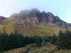
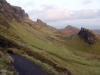
We hiked up the Old Man of Storr and made it all the way to the summit:
http://en.wikipedia.org/wiki/The_Storr


My brother hanging off the summit. 2000 foot drop. Not happy about that.
I enjoyed the hike so much I went back in March and brought my parents. We made it halfway up to the Old Man (the main defining feature of the range) and hit a whiteout. The wind was tunneling through the gaps between the rocks and blowing the 2 feet of snow all over the place. We decided that without crampons and axes it was best we didn't try to make it to the summit. Damn the view would have been nice though. I haven't uploaded any photos from March yet but i'll post some later. I managed to get some good shots despite the whiteout conditions.
We also did parts of Ben Nevis in December.
http://en.wikipedia.org/wiki/Ben_Nevis
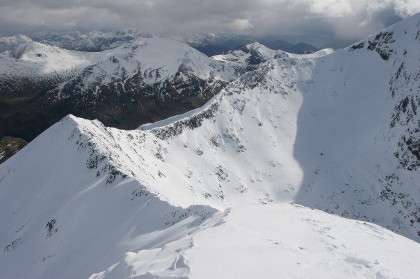
Too much snow in March. Big destination for ice climbing though. I highly recommend the highlands though. I can hook you up with all the best B&B's. Sorry for the long post. I like photos.
[Edited on August 18, 2010 at 11:18 AM. Reason : s]8/18/2010 11:10:27 AM |
TerdFerguson
All American
6570 Posts
user info
edit post |
^pimp pics and location. Def a part of the world I would like to check out one day.
I've always wanted to do some backpacking in the scottish/English countryside since I first saw the opening scenes of American Werewolf in London, lol.
and since learning about their "glamping" culture
http://online.wsj.com/article/NA_WSJ_PUB:SB125088561476349971.html
more to witness it than actually participate tho 8/18/2010 11:30:26 AM |
se7entythree
YOSHIYOSHI
17375 Posts
user info
edit post |
we plan on going back to glacier nat'l park next summer. i want to camp a couple of days, backpack in somewhere cool & stay a night, then go stay in a cheap ass hotel for a few nights too. we'll have to try to make lodging costs < flight costs bc tickets are expensive. i love that place and want to get in some real hiking next time. up to a glacier would be awesome. 8/18/2010 11:38:51 AM |
Prospero
All American
11662 Posts
user info
edit post |
come out to Colorado and hike some 14'ers, we got about 50 of 'em and everything from 1 mile hikes (scrambling) to class 5 rock climbing
a couple 14'ers bagged:
Mt. Lincoln - 14,286 ft
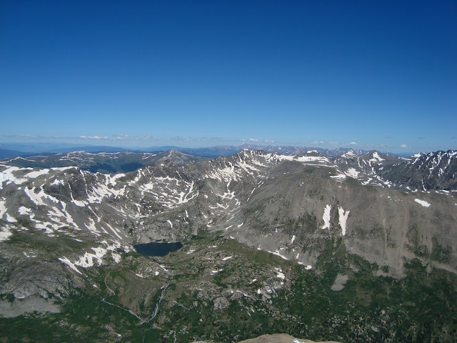
Mt. Harvard - 14,420 ft
My wife & dog:
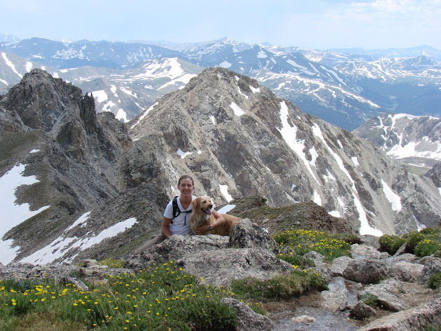
Quandary Peak - 14,271 ft
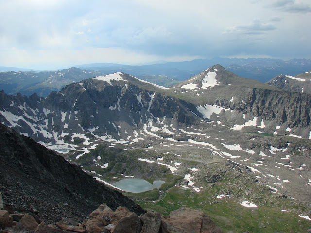
Pikes Peak - 14,115 ft
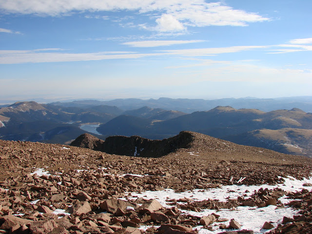
Down in Albuquerque I hiked the Sandia Mountain range with a buddy, there was about 1-2 feet of snow and 11'F high with winds at 30mph at the crest
Sandia Crest - 10,678 ft
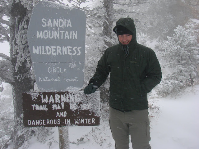
here you can see the 30-60mph winds do to the trees on the crest:
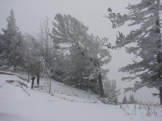
[Edited on August 25, 2010 at 12:05 PM. Reason : .] 8/25/2010 11:56:42 AM |
neodata686
All American
11577 Posts
user info
edit post |
yeah I wanna get back out to Colorado. It's been like 8 years. Can't remember which 14'ers we did. So jealous you live out there. I need to move.
^ah i love snow!! I need to post my March highland pictures. Although most of them you can't see anything because visibility was so poor and we were on our hands and knees half the time so we weren't blown away.
[Edited on August 25, 2010 at 12:08 PM. Reason : s] 8/25/2010 12:04:10 PM |
Prospero
All American
11662 Posts
user info
edit post |
Oh and here's an igloo I built in Washington, down in a meadow at the base of Mt. Rainier
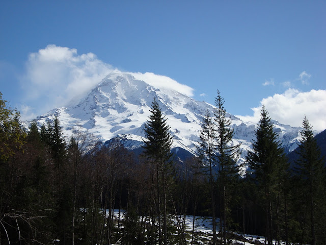

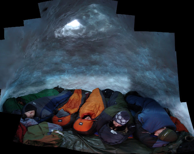 8/25/2010 12:08:36 PM |
Rush
Veteran
403 Posts
user info
edit post |
REI Outlet is having a 50% off all camping gear sale. Most of these items are just a little less than normal prices but you can find a couple bargains. It wont fit me, but they have a Medium z55 for $36 8/27/2010 6:17:16 AM |
quagmire02
All American
44225 Posts
user info
edit post |
^ their labor day sale (up to 30%) started today, too 8/27/2010 7:41:48 AM |
se7entythree
YOSHIYOSHI
17375 Posts
user info
edit post |
^^holy crap that's awesome! 8/27/2010 8:42:42 AM |
HockeyRoman
All American
11811 Posts
user info
edit post |
Stone Mountain, NC -- GO THERE! It was awesome!  It's a really nice place for a day hike. It's a really nice place for a day hike. 8/30/2010 7:08:04 PM |
MeatStick
All American
1165 Posts
user info
edit post |
Oh man...SO tired!!
Made it from Carver's Gap to Damascus in 7 days. I feel tired as hell. BUT...best experience of my life. I'm now really really determined to do the AT by myself!!!
Thanks for all the input/help, y'all!! 9/3/2010 11:24:37 PM |
adam8778
All American
3095 Posts
user info
edit post |
Nice! That is an awesome part of the world around there. 9/4/2010 2:25:57 AM |
TheBullDoza
All American
7117 Posts
user info
edit post |
oh man, the igloo is AWESOME!!!
^ agreed!
I've had too much fun in that area 9/7/2010 12:03:01 PM |
Johnny Swank
All American
1889 Posts
user info
edit post |
Sneaking out to the AT for a week. Starting at Springer and heading north to somewhere around Franklin. Haven't been there since I finished my thru-hike. That was Jan 11, 2000, and I was freezing my ass off. 9/7/2010 12:25:09 PM |
se7entythree
YOSHIYOSHI
17375 Posts
user info
edit post |
anybody been out to cades cove? that might be our next trip. 9/15/2010 11:06:11 PM |