eyewall41
All American
2251 Posts
user info
edit post |
Except in those places there are occasional disasters with years in between. Sandbars shift all of the time, and it is constant maintenance to try and make them permanent land areas when they are not. Their shifting is also not a natural disaster or extreme event like a large earthquake, mud slide, hurricane or anything else. It is just what they do. The comparison just doesn't make any sense.  12/6/2013 6:50:47 AM 12/6/2013 6:50:47 AM
|
dtownral
Suspended
26632 Posts
user info
edit post |
Has there been a year when the State has not had to entirely rebuild Hwy 12 through Pea Island? 12/6/2013 8:37:02 AM |
stowaway
All American
11769 Posts
user info
edit post |
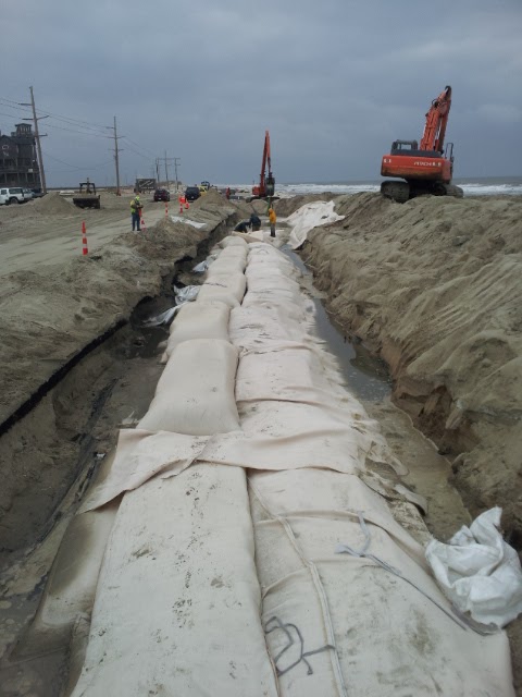
they've never had to "entirely" rebuild 12. Only during major storms have small sections of 12 needed repair. Irene and Isabel have been the only ones to create new inlets and breaches in the past 10 years and Sandy damaged part of the road, but not a full breach. Parts of 12 in Kitty Hawk have had problems as well but the complete lack of a beach for the past 10 years, plus KH insisting on keeping open spots in the dunes instead of walkovers has made the dune line very vulnerable. They are now doing the walkovers and making the dune line solid, and beach nourishment paid by the county and towns is going to start and widen the beach much like Nags Head was 2 years ago, and they've fared incredibly well in all of the storms.
In all of these cases it's been a lack of legally being able to do a proper repair that has caused further problems with even noreasters. 12/6/2013 12:29:11 PM |
dtownral
Suspended
26632 Posts
user info
edit post |
those "small" sections had to be completely rebuilt, they had to start from scratch 12/6/2013 12:34:23 PM |
eleusis
All American
24527 Posts
user info
edit post |
all they do to "rebuild" Hwy 12 is plow the sand off of the pavement most years. I've been involved with 2 small highway projects over the last 10 years due to hurricanes, which is pretty good when you consider the tax revenue generated by those roads remaining open. 12/6/2013 12:34:27 PM |
dtownral
Suspended
26632 Posts
user info
edit post |
absolutely untrue, they had to completely reset and change the alignment (its now as far west as the State's property goes so if it gets washed out again the State will have to buy more property)
[Edited on December 6, 2013 at 12:42 PM. Reason : .] 12/6/2013 12:42:22 PM |
eleusis
All American
24527 Posts
user info
edit post |
they use a local grid down there, not the state grid. The property lines shift with the road. In areas where they've had to realign the road, like at Canadian Hole, the National Parks people have always allowed them to adjust the road right-of-way without having to buy anything. 12/6/2013 12:55:33 PM |
dtownral
Suspended
26632 Posts
user info
edit post |
which means that they had to completely rebuild from scratch, like i said 12/6/2013 1:32:31 PM |
eleusis
All American
24527 Posts
user info
edit post |
a less than 2 mile stretch. quit acting like they had to rebuild the entire 70 mile stretch of highway. 12/6/2013 1:35:55 PM |
dtownral
Suspended
26632 Posts
user info
edit post |
and you can stop acting like adding miles of 10' sandbags and constructing a road with a new alignment is just scraping off some sand and paving 12/6/2013 1:38:38 PM |
eleusis
All American
24527 Posts
user info
edit post |
they scrape the road every year due to the noreasters pushing the dunes over on the highway, and yes it really is just that simple of a procedure.
they don't sandbag either, they pumped dredge sand out of Canadian hole into the washout area to fill it in. That's why it's called Canadian Hole, because there's an artificial bowl there now from where it was used as a borrow pit.
[Edited on December 6, 2013 at 1:46 PM. Reason : .] 12/6/2013 1:43:55 PM |
dtownral
Suspended
26632 Posts
user info
edit post |
[Edited on December 6, 2013 at 2:35 PM. Reason : stop being wrong, dude]
12/6/2013 2:33:45 PM |
Str8BacardiL
************
41737 Posts
user info
edit post |
They should move/close/abandon NYC because lower Manhattan is susceptible to flooding. 12/6/2013 2:47:52 PM |
Bullet
All American
27842 Posts
user info
edit post |
they should build towns inside volcanoes and sea caves 12/6/2013 2:56:11 PM |
eleusis
All American
24527 Posts
user info
edit post |
^that's Mirlo Beach along the section where the road undermined but was not cut in two. The Avon inlet wasn't sandbagged. 12/6/2013 3:55:54 PM |
dtownral
Suspended
26632 Posts
user info
edit post |
You're embarrassing yourself dude 12/6/2013 4:46:42 PM |
stowaway
All American
11769 Posts
user info
edit post |
trying to think what you mean by avon inlet. There was a lot of overwash at the north end of Buxton (still nothing like Mirlo or New Inlet), but for anything north of that any standing water was from the rain or soundside flooding. The isabel inlet was at the north end of Hatteras Village and hasn't really had a problem since Isabel. 12/6/2013 4:55:15 PM |
eleusis
All American
24527 Posts
user info
edit post |
yeah, I'm not thinking of the Isabel inlet, although that was dredged sand also. I'm thinking of the location of the old Buxton inlet where something (noreaster?) cut it out around 2002 and DOT had to relocate the road and pump sand back into the area. Whatever it was, it shifted the beachline so bad that we had to relocate the transmission line that so that they could build the road back in the old powerline location. It's at the same spot where the beach washed out in the 60's and they filled it in with the sand from Canadian Hole. 12/6/2013 9:11:14 PM |
Jax883
All American
5562 Posts
user info
edit post |
Local news outlet has a relatively easy to read synopsis (four parts) of the history of the bridge replacement efforts and appears to at least attempt objectivity:
Part 1
http://outerbanksvoice.com/2014/03/16/finger-pointing-ignores-complexities-of-bonner-bridge-saga/
Part 2
http://outerbanksvoice.com/2014/03/19/pea-island-corridor-snarled-progress-on-plans-for-new-bridge/
Part 3
http://outerbanksvoice.com/2014/03/24/dare-mounted-a-late-rally-against-17-mile-bonner-replacement/
Part 4
http://outerbanksvoice.com/2014/03/30/bog-of-regulations-and-interests-mired-progress-on-new-bridge/ 4/5/2014 11:44:54 AM |